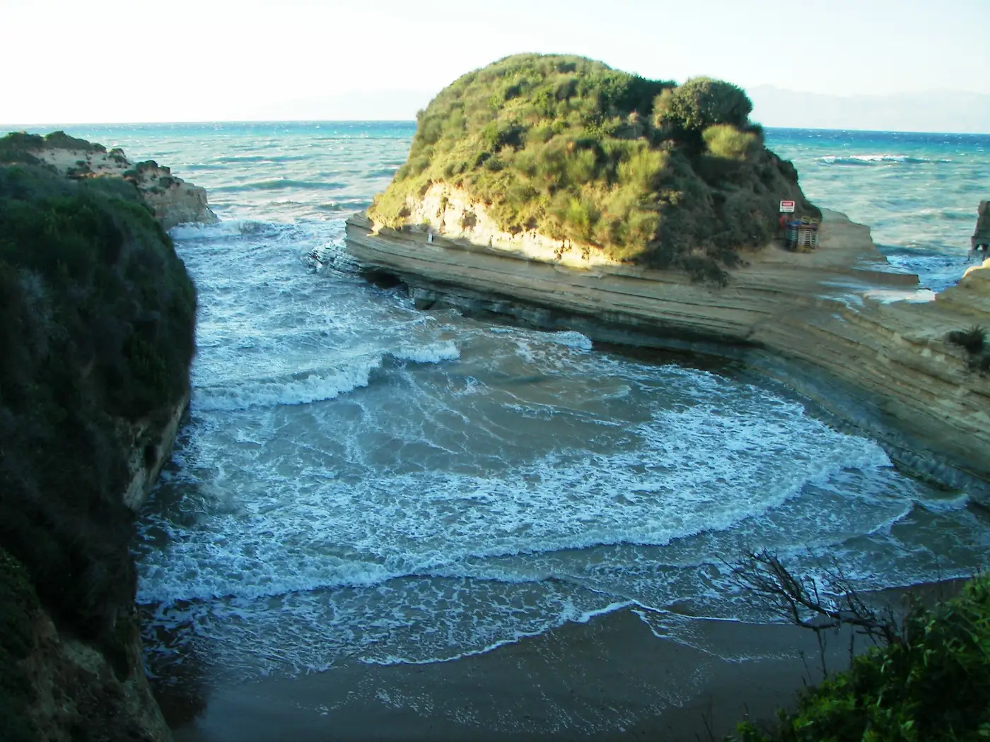
It is not a sand beach. People lay their towels on flat rock shelves, and sand turns up in patches rather than as something you can spread out on.
The rock is soft, this coast is being actively reshaped, and what you saw in the photograph is the sea’s current draft rather than a fixed landmark. Where it ranks against the best beaches in Corfu belongs to that page, and Corfu itself sets out the corner it sits in.

Diagram by Greece Trips. Free to reuse with credit - CC BY 4.0.
A rock coast with coves in it, not a beach with rocks at one end
The shape is what the photographs never explain. Spurs of rock run out into the sea like fingers, with small coves in the gaps between them, steps and paths cut down to the water, and undercuts and low openings at sea level that the guides call caves.
Underfoot it is stone: flat shelves that people put towels on, coarse sand in patches rather than a beach of it, and sand on the floor of the coves under the water. Local guides call the rock sandstone, one calls it clay, and the bus operator’s own page calls it limestone, so this page describes it instead of classifying it: soft, pale, and cut in visible horizontal bands.
Sidari’s own long sand beach is a separate place a short walk east along the front, which one guide puts at five to ten minutes on foot.
People scrape the pale clay off the rock and smear it on themselves, and local sources report it is purported to have healing and detoxifying properties. Sunbeds and drinks are there in season, run by businesses that turn over often enough that naming one here would be a disservice.
The channel, and the story people tell about swimming it
Canal d’Amour is French for channel of love. The Greek name circulates two ways, as Kanali tou Erota and as Kanali tis Agapis, and the bus operator that runs there uses the second.
The story is told locally, and it is told more than one way. In one telling, a couple who swim through the channel together will stay together. In another, whoever swims through it will meet the person they marry on the other side. A third has it that a woman who passes through will soon find her true love. Guides also report that a French visitor who swam here gave the place its name. The variation is the honest part of it, and the sources that carry the story do not say who told it first.
People swim the channel, jump from the rock into it and snorkel into the low openings along the sides. What is there is open sea between two rock walls, rock at the sides rather than a shelving shore, and water that moves with the wind. That is the ground; what to do about it on the day belongs to the person standing on it.
Soft rock on a coast that is being redrawn
The redrawing is current, not geological.
On 19 February 2026 protothema.gr, a Greek national outlet, reported serious erosion at the Canal d’Amour: the sea has taken sections of the frontage, and businesses that have traded there for decades now sit close to the edge. That is reporting of local testimony, and the article publishes no measurement of its own. Two years earlier huffingtonpost.gr ran Dr Spyros Krokidis on coastal erosion in the Ionian (31 March 2024), drawing on the Laertis project and the AETHER programme: it names Sidari among the coasts showing increased erosion vulnerability and puts more than 30 percent of Corfu’s coastline in the high or very high band.
The record is public. The free photographic archive of this cove on Wikimedia Commons runs from 1990 through 2006, 2014 and 2018 to July 2025, and the frames do not show the same rock.
This page names no arch, no stack and no particular ledge. Whatever is fenced, fallen or newly cut on the day you arrive is the site. One 2026 visitor account of a collapsed way down to the water is evidence that the ground moves, not a report on conditions today. How we check and date these pages is set out in our editorial policy.
Getting there, and the hour that decides the visit
The coves sit at the island’s far north-west corner, at the western end of Sidari, with Peroulades and the cliffs beyond. Staying in Sidari, you walk. From Corfu Town you cross most of the island; four guides give four different distances for that, so this page prints none.
KTEL Corfu runs the green intercity buses, route A2 serves Sidari, and the operator’s own destination page puts the journey at about an hour and a quarter. Take the current timetable and fare from KTEL Corfu rather than from any guide, this one included. Guides describe private car parks operating at the coves in season, with free parking back in the resort a short walk away; the wider mechanics are in getting around Greece.
The coves are small and they fill, so the hour you arrive changes the visit more than the day you pick: early morning, or the last of the afternoon. Unless you are swimming, this is well under an hour. May, June and September are the months, and what each month is actually like has the detail.
Whether it earns the drive, and what else is in the corner
Worth the walk if you are in Sidari or the north. Worth a morning if you are already going up to the island’s top corner, which also holds Cape Drastis and the sunset cliffs at Loggas near Peroulades. A poor use of a day’s drive from the south, if what you want is a beach.
That split is the whole of the review record: 4.0 across 4,708 reviews when we read it in July 2026, divided between people who came early and treated it as a walk and a swim, and people who drove a long way in August expecting sand. It is an expectation problem rather than a problem with the place.
For sand on the west coast, Agios Gordios; for coves under green headlands, Paleokastritsa; for the group Corfu sits in, the Ionian islands.
Canal d’Amour, Corfu: common questions
What is the Canal d’Amour in Corfu?
The Canal d’Amour is a narrow water channel cut through soft, layered rock at the western end of Sidari, on Corfu’s north coast. It is one slot in a run of rock fins with small coves between them, and it is a rock coast rather than a sand beach. The name is French for channel of love, after a story told locally about swimming through it.
Is the Canal d’Amour a sandy beach?
No. The coves are framed and floored with rock, people lay their towels on flat rock shelves, and sand turns up in patches rather than as a beach. Sidari’s own long sand beach is a separate place a short walk east along the front, which one guide puts at five to ten minutes on foot.
What is the legend of the Canal d’Amour?
The story told locally is that a couple who swim through the channel together will stay together, and in another telling that whoever swims through it will meet the person they marry on the other side. Guides also report that a French visitor gave the place its name. The story varies between tellings, and the sources that carry it do not say who told it first.
Can you swim through the Canal d’Amour?
People do, and you will probably see it happening: swimming the channel, jumping from the rock and snorkelling into the low openings along the sides. What is there is open sea between two rock walls, rock at the sides rather than a shelving shore, and water that moves with the wind. Whether to get in is a judgement for the person standing on the rock, not for a web page.
How do you get to the Canal d’Amour from Corfu Town?
KTEL Corfu’s green intercity buses serve Sidari on route A2, and the operator’s own page puts the journey at about an hour and a quarter. From anywhere in Sidari you walk to the coves. Take the current timetable and fare from KTEL Corfu. Paid car parks operate at the coves in season, with free parking back in the resort.
When is the best time of day to visit the Canal d’Amour?
Early morning, or the last part of the afternoon. The coves are small and they fill, and crowding is the dominant complaint in the review record, which averaged 4.0 across 4,708 reviews when we read it in July 2026. For the season, May, June and September are the months to aim for.
Is the Canal d’Amour worth visiting?
Yes, if you treat it as what it is: a walk, a look and possibly a swim, well under an hour unless you stay in the water, best from a base in Sidari or the north, and best early. Skip it if you are driving most of the length of the island in August expecting a beach day. The rock is soft and this coast is being reshaped, so the formation in the photograph is not a guarantee.
Go early, and take the cove you find
You are going to lie on rock in a small cove, with a slot of open water beside you and the resort’s sand beach out of sight round the front. Go early, take whichever cove has room, and give it the hour it is worth rather than the day it is not.
Then take your own photograph, because the shape you get is the shape the sea has cut so far.
The only booking this corner really needs is a bed in it, and where to stay on Corfu breaks the island down area by area.
Last checked July 2026. Re-checked here: the erosion reporting, the bus route and journey time, and any sentence about the current shape of the rock. The legend is not re-checked, because a story does not go stale. No price, fare, parking charge, distance in kilometres or venue name appears on this page by design.