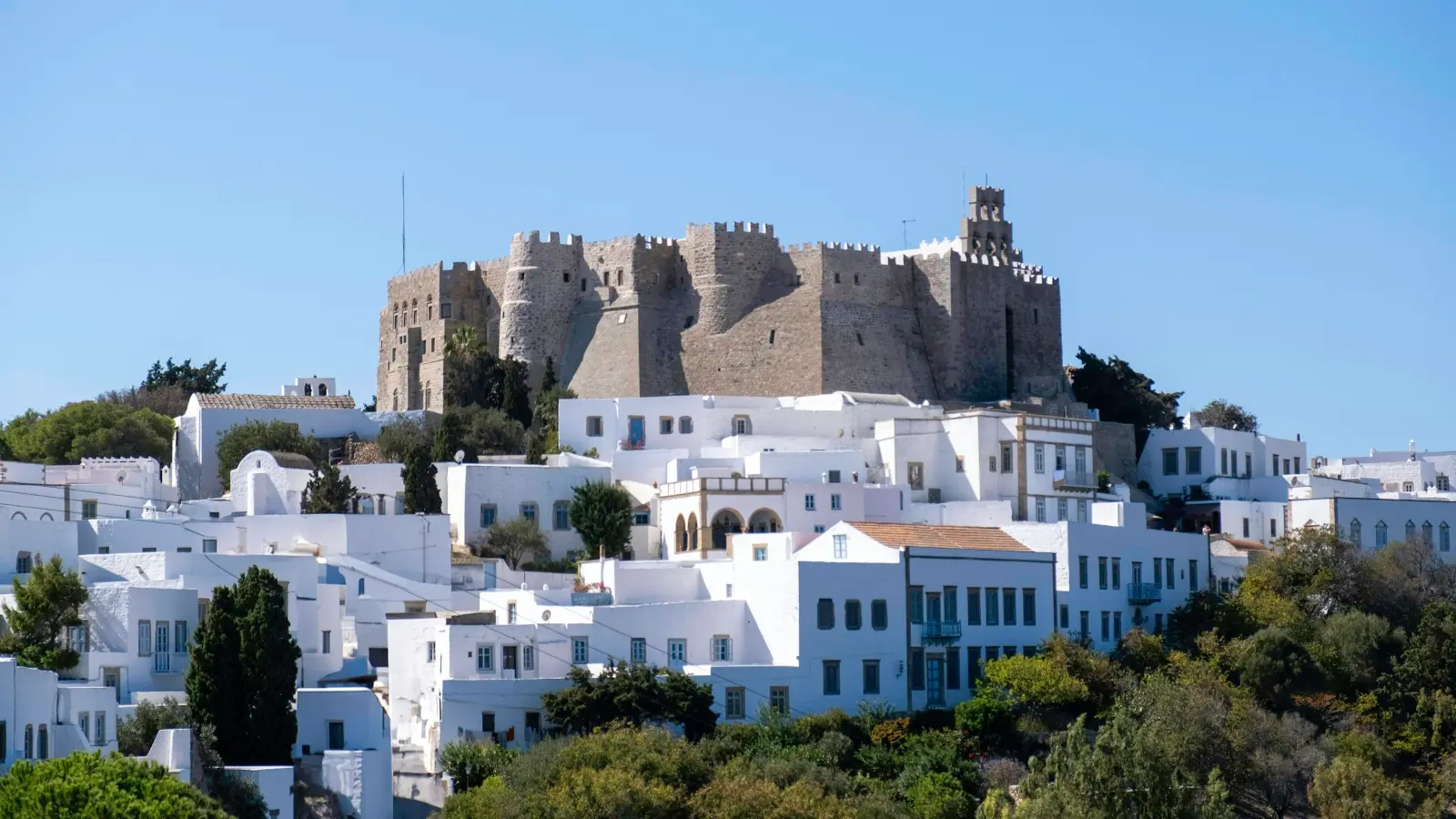
Island group
Dodecanese, South Aegean, Greece; in the eastern Aegean off the west coast of Turkey, near ancient Ephesus
Size and population
about 34 km2; roughly 3,300 residents (3,283 at the 2021 census). Highest point Profitis Ilias, 269 m
Airport
none; Patmos is reached only by ferry. Nearest airports are Kos (international), Leros and Samos (smaller)
Distance from Piraeus
roughly 145 nautical miles; the direct crossing runs from about seven hours to twelve depending on the boat’s stops, and is often taken overnight
UNESCO
the Chora of Patmos with the Monastery of Saint-John the Theologian and the Cave of the Apocalypse, inscribed 1999
Monastery founded
late 11th century, commonly given as 1088; sources conflict
Visiting hours
the monastery publishes one schedule covering itself and the cave: open every morning, shut in the early afternoon, reopening on only a few afternoons a week
Best months
June, July and September; late May and early October quieter still; August the hottest, busiest and priciest
Travel details last checked July 2026.
Where Patmos is, and why it stays this quiet
The island of Patmos sits in the Dodecanese, in the eastern Aegean, off the west coast of Turkey and near ancient Ephesus. It is one of the northernmost islands in the group, roughly 145 nautical miles from Piraeus, the port of Athens. It has no airport, so you reach it only by ferry.

Diagram by Greece Trips. Free to reuse with credit - CC BY 4.0.
The scale is small. Patmos covers about 34 square kilometres and had around 3,300 residents at the 2021 census, which makes it less a landscape than a single settlement strung between a port and a hilltop. Its highest point, Profitis Ilias, reaches 269 metres, and you can drive the length of the inhabited island in well under half an hour.
That smallness is not an accident of fashion. Two facts keep Patmos calm: it has no airport, and it lies a long way from Athens. A visitor cannot fly in for a weekend, and the casual day-tripping crowd that fills the easier islands never quite arrives. What is left is a slower, more deliberate kind of traveller and a reputation that runs upmarket rather than budget. The island is not undiscovered and it is not a secret. It is simply small and hard to reach, and it has stayed quiet for that reason.
Four places anchor the map. Skala is the port, where every ferry lands. Chora is the whitewashed capital on the hill, gathered under the monastery walls. Grikos is a calm bay to the south, and Kampos a beach village to the north. Learn those four names and you can hold the whole island in your head.
You can place it against its neighbours on the Dodecanese islands page, or see where it sits on the map.
The name, the exile, and what Patmos means
What Patmos means is genuinely unsettled, and the honest answer is that no one is sure. The name is older than the Greek that surrounds it and is probably pre-Greek in origin, which is why the confident translations you find online do not agree with one another. Scholars offer tentative threads rather than a definition: a loose link to an old root meaning something like to tread or to walk, a myth tying the island to Poseidon, and an older mythic name, Letois, connected to the goddess Artemis. Any of these may hold a grain of the truth. None is secure enough to state as fact.
The significance that made the name famous is easier to trace. According to Christian tradition, the Apostle John was exiled to the isle of Patmos late in the first century, commonly dated to around 95 AD under the Roman emperor Domitian. On the island, tradition says, he received the visions recorded as the Book of Revelation, the last book of the New Testament, which names the place directly: “I John … was in the isle that is called Patmos” (Revelation 1:9). That single sentence is why a bare-rock island of a few thousand people carries the weight it does, and why two very different kinds of traveller step off the same ferry.
None of this settles what the visions mean. That is a question for a different kind of book. What the island offers is the place itself, and the next thing to understand is how you actually see it.
The Cave of the Apocalypse and the Monastery of Saint John
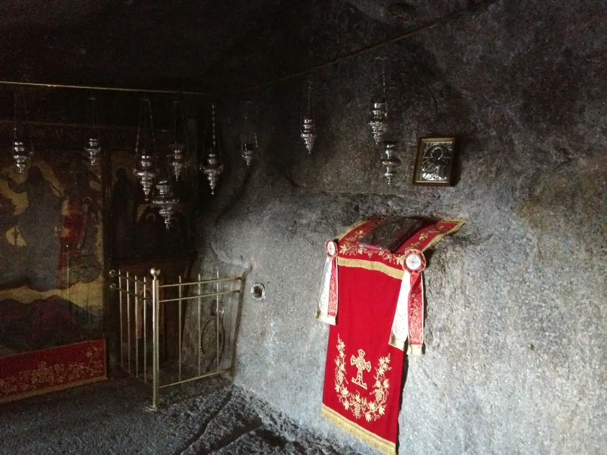
The Cave of the Apocalypse is a small rock grotto on the road between Skala and Chora, roughly halfway up the hill, where Christian tradition holds that John received the visions of Revelation. It is now an Orthodox chapel and an active place of pilgrimage, and it forms part of a UNESCO World Heritage Site.
The cave and the monastery are best understood as one thing rather than two. Together with the town of Chora, they were inscribed on the UNESCO list in 1999 under a single name: the Chora of Patmos with the Monastery of Saint-John the Theologian and the Cave of the Apocalypse. The parts are inseparable, but they are not in the same spot, and that trips up first-time visitors.

Diagram by Greece Trips. Free to reuse with credit - CC BY 4.0.
Inside, the cave is dim, low and small, an active chapel rather than a museum. Guides point out the features that tradition attaches to the story: a hollow in the rock said to be where John rested his head, a ledge that served as a desk for his scribe Prochorus, and a triple fissure in the ceiling read as a sign of the Holy Trinity. You do not come for grandeur. You come because this specific rock is the reason the island holds the place it does in the imagination.
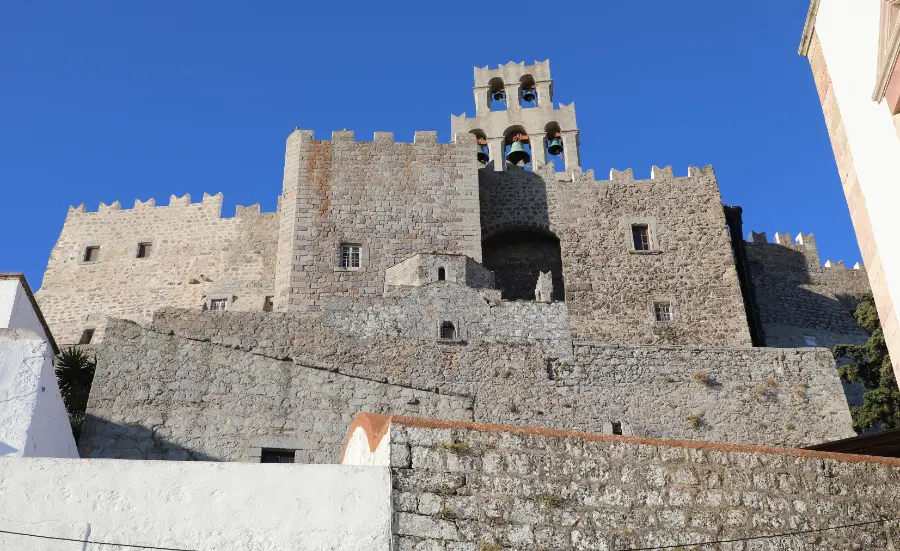
The Monastery of Saint John the Theologian crowns the hilltop above, and it looks the part: a fortress of high, blank walls built from the island’s dark volcanic stone, put up to hold off pirates as much as to house monks. It was founded in the late 11th century, a date commonly given as 1088, though the sources conflict and you will see other years cited.
Both places are living religious sites, and they are visited on their terms, not yours. Visitors consistently report a modest dress code applied at the door: shoulders and knees covered, for everyone. Women are commonly expected to wear a skirt or a wrap rather than shorts, and cover-ups are usually lent to anyone who arrives unprepared, though the finer points vary between sources and are worth checking rather than assuming.
Timing matters as much as dress. The monastery publishes one schedule covering both itself and the cave, and its shape is the thing to plan around: both open in the morning and shut in the early afternoon, and on most days they do not reopen at all, with only a few afternoons a week available. Feast days and the seasons move things again. So the practical rule is simple. Go in the morning, and read the current table on the monastery’s own site before you climb rather than trusting a timetable you found in a guidebook.
For how to behave inside a Greek church or monastery more generally, see Greek etiquette and customs.
Chora, Skala and the island’s four faces
Patmos reads as a two-part island, and the gap between its halves is where its character lives.
Skala is the working port and the practical centre. Every ferry lands here, and so does everything that follows from that: the shops, the cafes, the car-hire desks, the boats out to the beaches. If you are on the island for a day off a cruise, Skala is where you start and probably where you stay. It is pleasant and busy rather than pretty.
Chora is the other half, and the reason to climb. It is the old capital on the hilltop, gathered tight under the monastery walls, and it is one of the few Greek settlements continuously inhabited since around the 12th century. The lanes are a dense white weave of chapels, archways and the tall stone mansions that sea captains and merchants built when the monastery made the island rich. In the evening the town draws inward to its main square, where a long dinner and a slow walk are the entertainment on offer.
Grikos and Kampos are the quieter secondary bases. Grikos is a calm bay on the south coast with a short strip of waterfront; Kampos is a beach village in the north. Either suits a traveller who wants to be near the water rather than in the middle of things.
The crowd, honestly, is discreet and well-heeled, with a strong Italian and domestic-Greek following, and the island stays notably calm even in August by the standard of the Greek islands. Evenings here are Chora’s square and Skala’s waterfront: a long dinner, a drink, the harbour lights. That is the shape of a Patmos night, and it is worth knowing before you arrive whether that is the night you want.
For how the Dodecanese link up if you want to build a longer route, see the island-hopping guide.
Beaches and the island beyond the monastery
Patmos has good beaches, but they are the supporting act, not the reason you came. Most are quiet or secluded coves rather than organised strips lined with sunbeds, and the island rewards a slow swim and an empty stretch of pebbles more than it rewards a full beach-club day.
The two most organised beaches sit on the north coast: Agriolivado, a sheltered sandy bay, and Livadi Geranou, which looks out on a small offshore islet. Lambi, up on the northern tip, is a pebble beach known for the smooth coloured stones that wash up on it, worth a look even if you do not swim. Psili Ammos, on the wilder south coast, is the one people make an effort for, usually reached on foot down a path or by a summer beach boat from Skala. Grikos bay has the easiest swimming close to a base.
The catch is that the beaches are spread around the island, and reaching them is a drive rather than a stroll from town. A rented car or scooter turns the whole coast into an afternoon’s choice; without one you are limited to what is near Skala and Grikos, plus whatever the summer beach boats can reach. Decide which of those suits you before you arrive, because it shapes where you stay.
Whether an island like this actually needs a car of your own is worth thinking through in advance; see getting around Greece.
Getting to Patmos: a ferry-only island
There are two realistic ways to reach Patmos, and neither of them ends in the air:
- The direct ferry from Piraeus. The boat from Athens is a long haul of roughly 145 nautical miles, and depending on how many islands it calls at, it runs from around seven hours to the better part of half a day. Several sailings are overnight ones. Book a cabin if you want to sleep and a deck seat if you would rather save the fare.
- Fly to a nearby island, then hop across. Fly from Athens to Kos, which has an international airport, or to the smaller airports on Leros or Samos, then take a shorter ferry or a high-speed catamaran the rest of the way.
Patmos has no airport of its own. That is a fact of the island rather than a gap in this guide, confirmed by the ferry operators and every map of the place, and it is the single most important thing to plan around. Which Greek islands do and do not have runways is laid out in which islands have an airport.
Frequency is a seasonal thing. The Piraeus boat runs year-round but thins out sharply outside summer, while the short Dodecanese hops from Kos and Rhodes run daily in season. The fast boats and the slow boats are a real trade-off: high-speed catamarans cost more and save hours, while conventional ferries are cheaper and slower. Both the timetable and the crossing time move with the season and the operator, so treat any figure below as a band to confirm on the day.
| Gateway | Route type | Roughly |
|---|---|---|
| Piraeus (Athens) | Conventional ferry, often overnight | Seven to twelve hours, depending on the stops |
| Kos | Ferry or catamaran hop | About an hour and a half |
| Leros | Short ferry or catamaran | About half an hour |
| Samos | Ferry or catamaran hop | Under two hours |
| Rhodes | Dodecanese-line ferry | About four hours |
One honest warning about a ferry-only island: the boat is the only way off, so a cancellation or a bad-weather day can leave you waiting. Build slack into the plan, and never connect a same-day international flight to a single afternoon ferry. If a boat is cancelled on you, what to do when a ferry is cancelled covers your options, and the mechanics of ferry travel in general are in Greek island ferries. The two most practical gateways are Kos, with its international airport, and Samos to the north.
When to go, and who Patmos suits
The best months for Patmos are June, July and September. You get warm, settled weather, everything open, and the island still at its calm best. Late May and early October are quieter again, with the sea usually still warm enough to swim at the start of October. The month to think twice about is August, the hottest, busiest and most expensive stretch of the year, when even a calm island fills up and rooms are booked long ahead.
One thing overrides the ordinary calendar: the religious one. Patmos is a living pilgrimage island, so Orthodox Easter and the major feast days transform it, with crowds, processions and some closures. For a pilgrim that is the whole point and the best time to come; for a traveller after a quiet swim it is a warning. Which weeks those are, and how much they change, is covered in Greek Easter and August.
Patmos suits some travellers plainly and disappoints others, and it is more useful to say which than to sell it to everyone. It rewards pilgrims and the religiously curious, couples and quiet-seekers, and culture travellers who want one calm, meaningful stop on a Dodecanese route. It is the wrong island for anyone whose trip needs nightlife, big beach-resort energy, or a long list of attractions to keep children busy. Those are fair things to want. They are just somewhere else.
As for how long, a day off a cruise or a single day-trip is enough to see the cave and the monastery and little more. Two to three nights is what lets the island’s stillness actually settle on you, with room for a beach, an evening in Chora and an unhurried second look at the monastery.
The wider seasonal logic is in the best time to visit Greece and why shoulder season wins on the islands.
Fitting Patmos into your trip
Patmos works when you plan around the two things that define it: the ferry and the monastery. Reach it with slack in your schedule rather than on a same-day dash, dress for the holy sites, come in June, July or September, and come for stillness rather than for a party. Do that and the island gives you exactly what it is famous for. Treat it as a beach week and it will feel like the wrong choice.
If Patmos is one stop on a longer eastern-Aegean plan, the rest of the group is laid out on the Dodecanese islands page, ready to build into a route with the calm one at its heart.
Patmos FAQ
Where is the island of Patmos?
Patmos is a small Greek island in the Dodecanese, in the eastern Aegean, off the west coast of Turkey and near ancient Ephesus. It lies roughly 145 nautical miles from Piraeus, the port of Athens. It has no airport, so you reach it only by ferry. It is one of the northernmost islands in the Dodecanese group, and you can see where it sits on the map.
What does Patmos mean?
The meaning of the name Patmos is uncertain and probably pre-Greek, and no single translation is secure. Scholars offer only tentative threads: a loose link to an old root meaning to tread or walk, a Poseidon myth, and an older mythic name, Letois, tied to the goddess Artemis. Treat any confident translation you find with caution; the honest answer is that the name’s meaning is not settled.
Why is Patmos important in the Bible?
According to Christian tradition, the Apostle John was exiled to Patmos late in the first century and there received the visions recorded as the Book of Revelation, which names the island in Revelation 1:9. That is why it is called the isle of Patmos, or the island of Revelation. It is remembered as tradition rather than as documented history.
Does Patmos have an airport, and how do you get there?
Patmos has no airport. You reach it by ferry, either on the direct boat from Piraeus, which takes roughly seven to twelve hours depending on its stops and is often an overnight sailing, or by flying to Kos, Leros or Samos and taking a shorter hop across of between about half an hour and two hours. The Piraeus boat runs year-round but far more often in summer; the short Dodecanese hops run daily in season. Confirm times close to your travel date.
How many days do you need on Patmos?
A cruise call or a single day-trip is enough to see the Cave of the Apocalypse and the monastery, but two to three nights is what lets the island’s quiet actually register. That gives you time for a beach, an evening in Chora and a second, unhurried look at the sites, which is where Patmos rewards you rather than just showing you the highlight.
What should you wear to the monastery and the cave?
Both are active religious sites, and visitors consistently report a modest dress code at the door: cover your shoulders and knees. Women are commonly expected in a skirt or a wrap rather than shorts, and cover-ups are usually lent to anyone who arrives unprepared, though the details vary between sources. Go in the morning: the monastery’s published schedule covers the cave too, and both shut in the early afternoon and reopen on only a few afternoons a week.
Plan by category
The Patmos guides
3 guides, each scoped to a decision you actually have to make.
 Attractions
Things to do
See the attractions →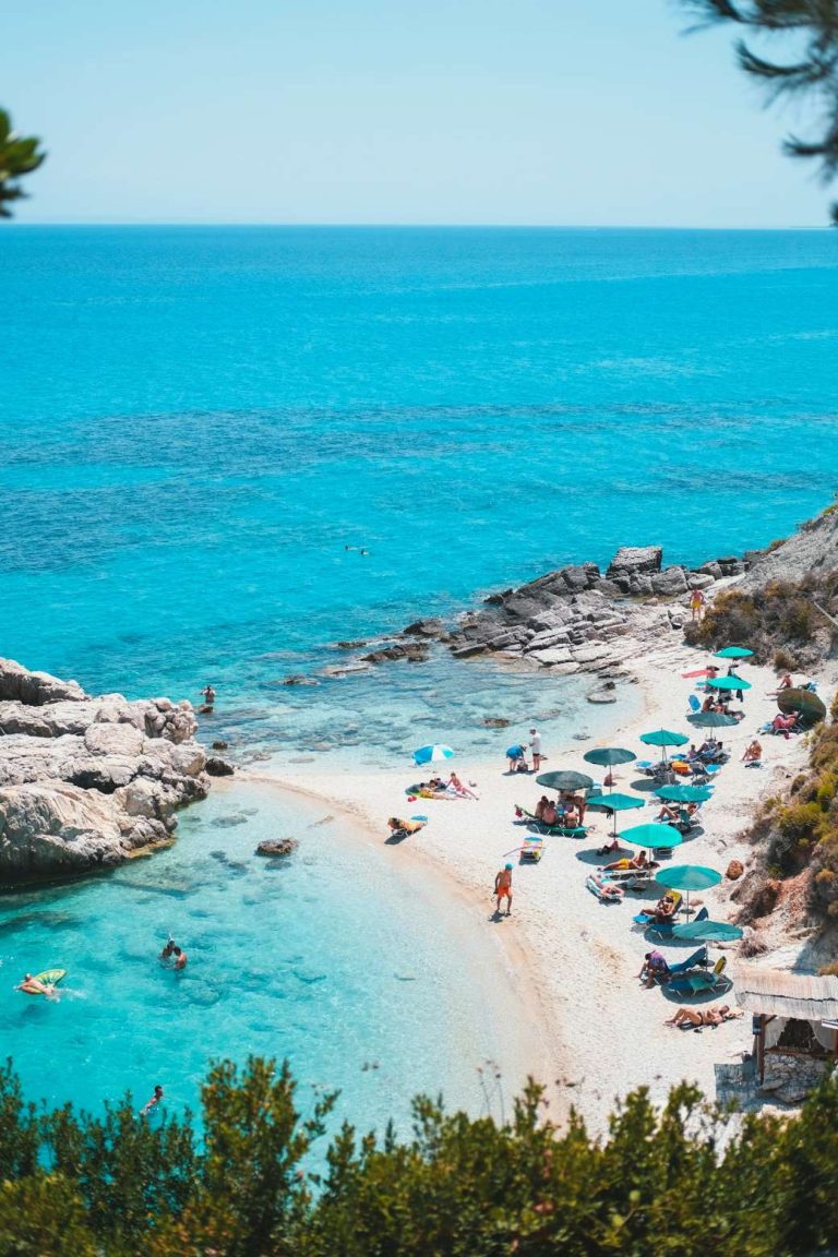 Beaches
The beaches
See the beaches → Day trips
Day trips
See the day trips →
Booking
We sell nothing and book nothing for you. Every guide on this page tells you how to arrange each piece yourself - which ferry operator, when to book, what to prebook and what to leave loose.