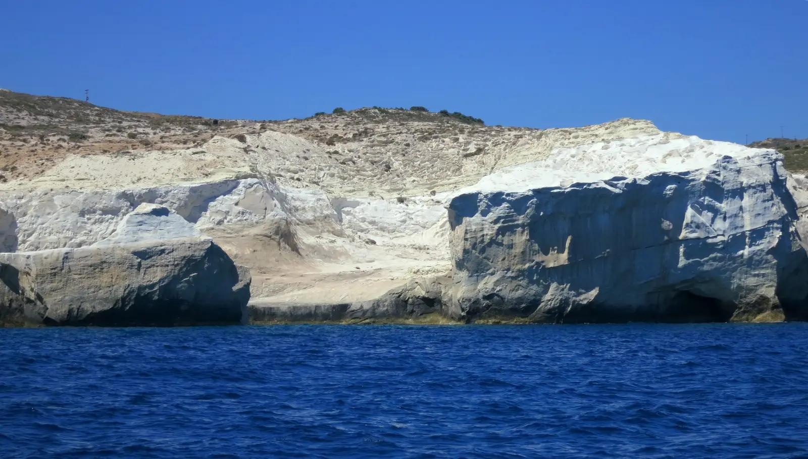
Everything practical about a visit falls out of that one sentence. Almost nothing grows on the rock, so the shade is whatever a couple of small trees and a few hollows can give you, which is not much. You cannot drive an umbrella pole into solid stone, which is why nobody rents you shade there and why bringing your own does not solve it either. The ground is bone white, so the light comes back up at you as well as down. And the inlet opens north, which means the wind, not the forecast temperature, decides whether you get in the water.
Everyone calls the place lunar. The unusual thing is that planetary scientists use it that way too, and mean it literally.

Diagram by Greece Trips. Free to reuse with credit - CC BY 4.0.
White volcanic tuff, laid down under the sea
The rock is white volcanic tuff, built by the deposition of submarine volcanic eruptions and then sculpted by wind and water over millions of years. That is the description of Anezina Solomonidou, a planetary scientist at the Hellenic Space Center, writing on the European Geosciences Union’s GeoLog blog in March 2025. The petrology sources add that the white deposits are largely pumice within the tuff, and that the graded beds in them record more than one eruption under water. Milos sits on the South Aegean Volcanic Arc, which is the same volcanic system that built Santorini, so if you are hopping between the two you are looking at two ends of one story.
Tuff, pumice: the sources use both words, because the deposits are largely fine-grained pumice within a tuff sequence. We are not going to adjudicate the petrology of a rock we are standing on in flip-flops. Call it white volcanic rock and you are right either way.
Now the part that rarely gets a mention. Sarakiniko is used as a terrestrial analogue for planetary research: scientists study it as a stand-in for environments on the Moon, Mars and Saturn’s moon Titan, and an EGU-sponsored workshop in 2024 on terrestrial analogues confirmed the site’s role in planetary science. The lunar landscape everyone photographs is not a copywriter’s metaphor. It is a working description used by people who plan spacecraft.
There are fossils embedded through the rock, which is why the layers matter and why you should look down as much as out. The Miloterranean geo-walking project, which maps a route past it, lists molluscs, gastropods, sea urchins and bivalves, along with pumice flows and thick diatomite deposits. That project is sponsored by the Ministry of Tourism and by Imerys, the mining company that works the island, which is worth knowing when you read it.
All of which comes back to your day. This is why the ground is smooth in places and abrasive in others, why the light is so hard at midday, and why the shade problem here has no solution you can buy. Milos is a volcanic island and it shapes the whole trip, which the Milos guide sets out.
What is not there, and the one thing that might be
The inventory at the rock is short: no sunbeds, no umbrellas, no beach bar, no taverna and no toilets. There is a car park. There may or may not be a van working it on the day you come.
That list is the consensus of the travel sources that have actually been there, and it is not a statement from an authority, because no authority publishes a list of what a beach does not have. The sources disagree on exactly one item, and it is the van: several say the beach has no facilities at all, while the most careful of them says a snack van may now work the car park and warns you not to rely on it being there. We have written the version that is true whichever of them is right. Carry your water in, because the water you carry is the water you have.
One source we could not read, and it is the one you would most want: the Greek National Tourism Organisation’s own Sarakiniko page. We have not read it, so nothing here rests on it.
The mechanism behind it is worth more than the list, because the list can change and the mechanism cannot: you cannot drive an umbrella pole into solid tuff. That is why nobody rents you shade there, and it is also why arriving with your own umbrella does not fix it.
As for shade, there is essentially none. A couple of small trees and a few shallow hollows in the rock, and they go early. We are not going to promise you a hollow.
So the packing consequence, and then we will stop lecturing you: bring water, bring more of it than you think, bring shade only if it is something that will stand on stone, and time the visit rather than endure it.
Getting there, and choosing your hour
Sarakiniko is on the north coast, roughly 3.5 kilometres from the port town of Adamas, at the end of a sealed road with a large car park at it. That distance is the travel field’s approximate figure rather than a surveyed one. On an island where half the good beaches want a boat, a rope or a dirt track, this is the one you can do on a whim, which is exactly the access taxonomy the Milos guide sets out.
The bus runs, and it does not run often: a couple of times a day, and not always reliably, is what the most careful travel source reports. We print no times and no fare here. The route and the verified fare are on the Milos guide, which is where they belong.
The alternative nobody mentions is a walk. The Miloterranean geo-walking project maps a coastal route of about 4.5 kilometres from Agios Konstantinos to Sarakiniko, with a bus stop at each end, running past the pumice flows, the diatomite, the fossils and the caves. The project’s own description is the honest one and we are not going to improve on it: the path is not always easy to make out, and you get down into the small ravine often with some difficulty. Read it and decide for yourself.
Then the hour, which is the real decision. Because Sarakiniko is the easiest famous place on the island to reach, everybody reaches it, and the rock fills through the morning. The light is low and long early and late, and hard and flat in the middle of the day, which is also when the shade you do not have is missed the most. We are not going to promise you an empty rock at sunrise, because the crowd is not ours to schedule and that promise fails every August.
The last variable is the wind. This is a north-facing coast, and the meltemi is what turns the water here choppy: the Milos guide carries that mechanism, and it is worth reading before you drive over on a blowy day. Which of the island’s beaches is worth which effort is on the Milos beaches page.
Book the car and the room yourself, and treat the boat day as the fixed point of a Milos trip rather than an extra: it is the one thing the wind can take away from you. The Milos guide sets out how the island is planned around it.
The swim is an inlet, not a bay
You do not wade into Sarakiniko. The water sits in a narrow inlet cut back into the rock, with a small strip of white sand at its head where you can walk in, and rock shelves running down both sides into deep water. The caves and hollows around it are the same erosion working at a smaller scale.
That shape decides your afternoon more than any tip could. Bags go on stone. A group ends up strung out along the shelves rather than sitting together on a towel. You get in and out over rock rather than over sand, and the ordinary business of a beach day, dropping your things and wandering into the shallows, does not really apply here.
People jump from the rock shelves into the inlet, and it is one of the things the place is known for. This page rates no jump, no spot and no height. No page can see the water you are standing over: the depth changes with the swell, and the sea moves while you are looking at it. Other guides will tell you which spot to choose. We will not, and we would rather say so out loud than pretend we can see the water from here.
One thing almost nobody prints: the wreck of the Africa, which ran aground on the east side in 2003, is visible from the rock.
And the honest expectation to leave with. If what you want is a long lazy beach day with a sunbed under an umbrella and a cold drink brought to you, this is not that place, and Milos has places that are. They are on the Milos beaches page.
The rock is under pressure, and not from your feet
Writing on the European Geosciences Union’s GeoLog blog on 21 March 2025, Anezina Solomonidou, a planetary scientist at the Hellenic Space Center, described construction at Sarakiniko: a luxury hotel being built with plans for expansion to further buildings, heavy machinery that she writes has removed sections of the rock formations, and foundations that she says threaten to alter the landscape permanently. She asked her readers to act on it.
That is her account, published on a geoscience body’s blog, and we are reporting it rather than adopting it: we did not see the machinery, and we are a travel page, not a party to it. Read her piece and make up your own mind. It is worth knowing that the rock in the photograph is a scientific site as well as a swimming spot, and that the people who study it are worried about it.
Come early, bring water, and look down
The rock is the beach. The shade you cannot buy, the umbrella you cannot plant, the hard light and the swim that is a slot rather than a bay all follow from what the ground is made of, and once you know that, you arrive with the right things and the right expectations.
From here: the rest of Milos, and which beach is worth which effort.
Last checked July 2026. The facilities, the bus and the state of the geo-walk are the three things re-checked on this page before every update. How we date and correct facts is in our editorial policy.
Common questions
What is Sarakiniko beach made of?
White volcanic tuff, largely pumice, laid down by submarine volcanic eruptions on the South Aegean Volcanic Arc and then carved back by the north wind and the sea. It is rock, not sand: the sandy part is a small strip at the head of the inlet. The description is from Anezina Solomonidou of the Hellenic Space Center, writing on the European Geosciences Union’s GeoLog blog in March 2025, and planetary scientists use the site as a terrestrial analogue for the Moon, Mars and Titan.
Is there any shade at Sarakiniko?
Essentially none. A couple of small trees and a few shallow hollows in the rock, and they are taken early. The durable half of the answer is the mechanism: you cannot drive an umbrella pole into solid rock, so shade cannot be rented there and cannot really be brought either. Time the visit early or late rather than enduring the middle of the day, and carry more water than you think you need.
Are there sunbeds, toilets or a taverna at Sarakiniko?
No sunbeds, no umbrellas, no beach bar, no taverna and no toilets at the rock itself. There is a car park, and a snack van sometimes works it, and you cannot count on the van being there on your day. That inventory is the corroborated consensus of the travel sources rather than a statement from an authority: the Greek tourism board’s own page could not be opened by us. Carry water in and carry your rubbish out.
Can you swim at Sarakiniko?
It is a narrow inlet with deep water between rock shelves and a small strip of sand at its head where you can walk in. People swim in the inlet, and people jump from the shelves. This page rates no spot, no jump and no condition, because no page can see the water you are standing over and the sea moves. One factual thing worth carrying: this is a north-facing coast, and the meltemi is the wind that turns the water here choppy, which the Milos guide explains.
How do you get to Sarakiniko from Adamas?
It is roughly 3.5 kilometres from Adamas on the north coast, at the end of a sealed road with a large car park, so a car or an ATV does it in minutes. The island bus serves it, though not often. There is also a walk almost nobody mentions: the Miloterranean geo-walk maps a coastal route of about 4.5 kilometres from Agios Konstantinos, with a bus stop at each end. The bus route and its verified fare are on the Milos guide.
How long do you need at Sarakiniko?
An hour or two is enough for most people. It is a rock, an inlet and a swim rather than a day out, and the honest thing to do is pair it with something else on the same trip. Photographers and swimmers stay longer, and the reason is the light: it is low and long early and late, and flat and hard in between. Where the rest of the coast is worth your day is on the Milos beaches page.
Booking
We sell nothing and book nothing for you. Every guide on this page tells you how to arrange each piece yourself - which ferry operator, when to book, what to prebook and what to leave loose.