Island
Evia (Euboea), Greece’s second-largest island after Crete, a long, narrow island (~180 km) off the country’s east coast
Getting there
by road over the bridges at Chalkida, about an hour north of Athens on the A1 (tolled, with a station at Afidnes), leaving the motorway at Schimatari; KTEL Evias coaches from Liosion, about an hour; direct trains from Athens Central Station, nearer an hour and a half; car ferries Arkitsa to Loutra Edipsou (~45 min), Oropos to Eretria (hourly), Rafina to Marmari (~1 hr, daily year-round), Agia Marina to Nea Styra, and Glyfa to Agiokampos. No ferry is required
Capital and gateway
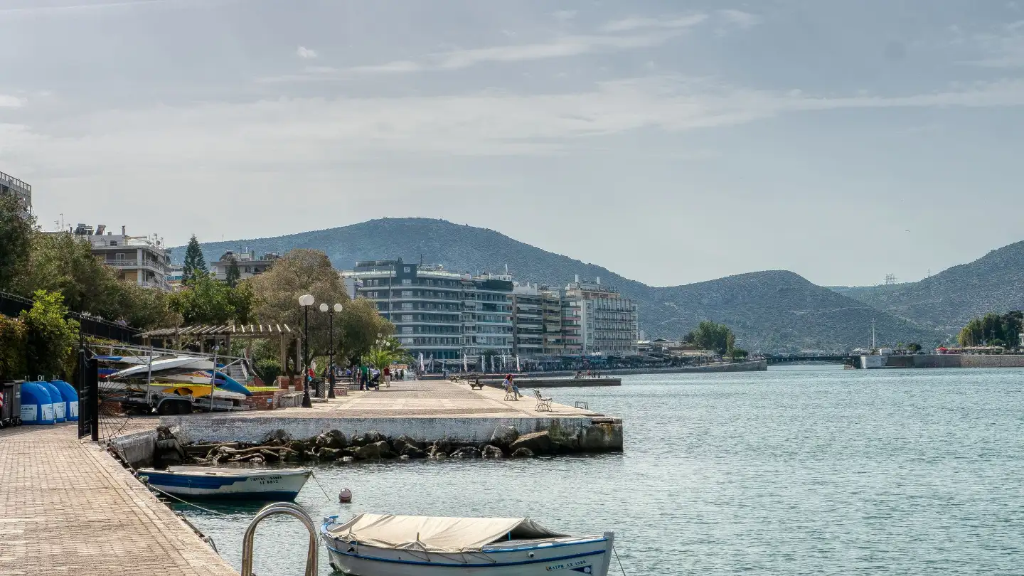
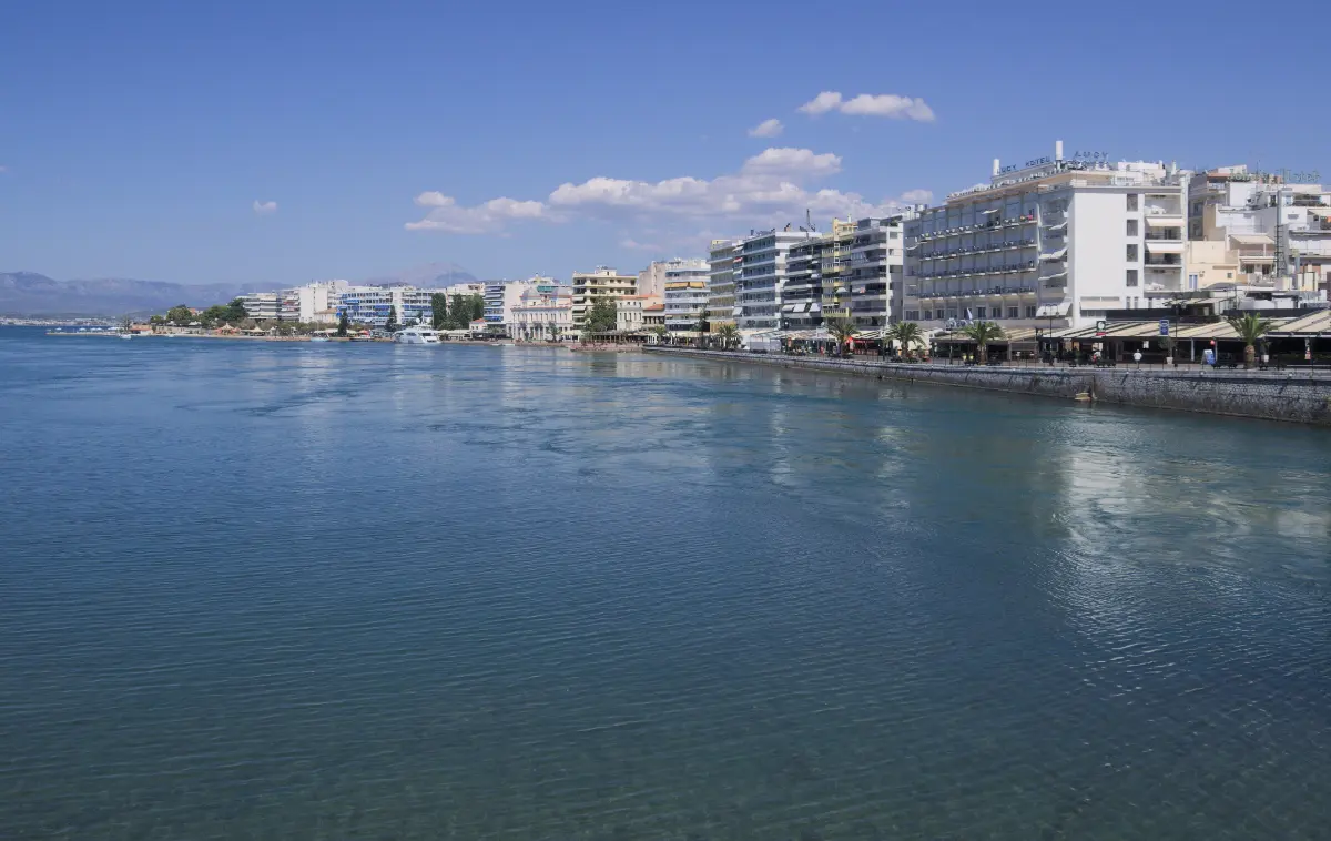
Chalkida, at the narrowest point of the Euripus strait, where an old sliding bridge and a newer high cable-stayed bridge cross; the high bridge carries the through-traffic, the old one is where you watch the current
Signature sight
the Euripus tidal current at Chalkida, which reverses on a near-daily rhythm with a brief still slack between reversals and runs strongest around the equinoxes
North
Loutra Edipsou (Edipsos) geothermal thermal springs, used since antiquity as the “Herculean baths”, a rare year-round Greek destination; the surrounding forests are part-way through a recovery from the August 2021 wildfire that specialists measure in decades
South and interior
Karystos and the medieval Castello Rosso; the Dragon Houses (Drakospita) of southern Evia, classical-to-Hellenistic dry-stone structures, the best known high on Mount Ochi; Mount Dirfys (~1,743 m), the highest peak, with Steni as the walking base; the Dimosari Gorge hike
Best months
May, June, September and early October for the sea and thinner crowds; August is busiest with Greek holidaymakers; northern Evia works in winter for the springs
Travel details last checked July 2026.
Evia, Greece: the second-biggest island you drive to
Evia, Greece, is the country’s second-largest island, and it is the rare one where the boat is optional. A bridge at Chalkida joins it to the mainland at the narrowest point of the Euripus strait, about an hour north of Athens, so you can put your own car on the road and drive straight onto the island without booking a ferry. That reshapes the whole trip. This is Evia island as a road trip rather than a boat holiday: a spine of roughly 180 km running from the belle-epoque spa coast in the north to the dragon-house mountains of the south, close enough to be a day or weekend trip from Athens.
Where Evia is, and why it barely feels like an island
Evia (also written Euboea) is Greece’s second-largest island after Crete, a long, narrow island running down the country’s east coast for roughly 180 km. It is separated from the mainland only by the Euripus strait, and joined to it by bridges at Chalkida, about an hour north of Athens.
Hold the island in your head as three zones, because you will use them for the rest of this page. The north is spa coast and pine country around Loutra Edipsou. The centre holds Chalkida, the capital, and ancient Eretria, on the flatter, gentler land closest to Athens. The south climbs into mountains around Karystos and Mount Ochi, where the roads narrow and the crowds all but disappear.
A single mountain spine runs the length of the island, dividing a wilder east coast that faces the open Aegean from a gentler west coast that looks back across the gulf toward the mainland. That divide decides where the calm beaches are, where the wind lands, and where the hiking is.
Chalkida sits at the pinch, the point where the strait narrows to a channel you could throw a stone across and where the bridges cross. It is the capital, the gateway and, for most visitors, the first stop.
Evia is bigger than every other Greek island except Crete, yet for travel it is grouped with the Sporades to its north-east rather than with the Cyclades most people picture when they think of Greece. You can trace the whole shape on the island map before you go.

Diagram by Greece Trips. Free to reuse with credit - CC BY 4.0.
Getting there: the Greek island where the ferry is optional
Most people simply drive. From Athens you take the A1 motorway north toward Lamia, leave it at Schimatari and cross the strait at Chalkida in about an hour. The A1 is a toll road on that stretch, with a toll station at Afidnes north of Athens, so budget for it. Here is how the options compare from Athens:
- Drive: the A1 motorway north toward Lamia, off at Schimatari, then across the bridge at Chalkida - roughly an hour, and the way most visitors arrive.
- Bus: KTEL Evias coaches leave from the Liosion intercity terminal in Athens through the day, every day, and take about an hour.
- Train: direct trains run daily from Athens Central Station to Chalkida, roughly every couple of hours, and take nearer an hour and a half than an hour - slower than the road, and worth knowing before you choose it.
- Car ferry: short crossings shortcut straight to a chosen end of the island rather than sending you the length of it.
Two bridges cross at Chalkida, and they do different jobs. The older one is a low sliding bridge in the middle of town that can pull aside to let ships through; this is where you stand at the railing to watch the strait’s current reverse. The newer one is a high cable-stayed bridge that arcs over the channel and carries the through-traffic, and it is what most drivers actually use. Competitors tend to blur the two into one; the distinction matters, because one is a road and the other is the show.
The ferry logic is worth understanding, because on a 180 km island a short crossing can beat driving the whole spine. The car ferries run from the mainland to specific ends of Evia: a north-western crossing lands on the Edipsos spa coast, a central crossing lands near Eretria, southern crossings reach Marmari and the Styra area, and a northern crossing serves the far north. Choose the one that matches where you are sleeping, and skip the long drive.
| Crossing | Which end of Evia it serves | Rough shape |
|---|---|---|
| The bridges at Chalkida | Central Evia, and by road the whole island | About an hour from Athens |
| Arkitsa to Loutra Edipsou | The northern spa coast | About 45 minutes |
| Oropos to Eretria | Central Evia | Hourly departures, a short hop |
| Rafina to Marmari | The mountainous south | About an hour, daily year-round, carries cars |
| Agia Marina to Nea Styra | The southern Styra area | A short crossing |
| Glyfa to Agiokampos | The Istiaia and far-north end | A short crossing, carries cars |
Public transport radiates out from Chalkida and thins as you go: buses serve the main towns well and the mountain villages and remote beaches rarely, which is why most visitors bring or rent a car. Read up on driving here and how the short ferry crossings work before you set off, and if you are flying in, renting a car for the trip at Athens airport puts you on the bridge within the hour.
The water that changes its mind: the Euripus tidal phenomenon
At Chalkida the current in the narrow Euripus strait reverses direction on a near-daily rhythm, and watching it is the first thing to do when you cross. The water runs one way for hours, slows, falls to a dead-still slack for a few minutes, then turns and flows back the other way. Around the equinoxes the pattern breaks: the current runs strongest and switches without the pause. The rough interval between reversals and the length of the slack are figures worth checking rather than trusting, because they shift and get misquoted.
The phenomenon has drawn observers since antiquity. Aristotle studied the strait and could not fully explain why the water behaved this way, and ancient writers puzzled over it for centuries after him. The mechanism is tidal: the two bodies of water on either side of the pinch fill and drain at slightly different rates, so the level is forever tipping one way and then the other through the narrows.
You do not need a boat or a ticket. Stand on the old sliding bridge in the town centre, lean on the railing, and watch the surface boil, still itself, and turn. It costs nothing and takes ten minutes, which makes it the natural first stop for anyone arriving over the bridge. For the wider picture of what the sea is like around Greece, the Euripus is the strangest corner of it.
Northern Evia: thermal springs and a forest coming back
The north pairs Greece’s most storied spa town with a coast that is still recovering from fire, so a visit here is part wellness break and part quiet support for a region rebuilding. Loutra Edipsou (Edipsos) is the anchor. Geothermal, mineral-rich hot water surfaces along the shore here and has been used since antiquity, when the springs were known as the Herculean baths, and a belle-epoque spa town grew up around them in the nineteenth and early twentieth centuries. Because the springs run hot in winter as well as summer, Edipsos is one of the few Greek destinations that works year-round.
In its heyday Edipsos was one of the fashionable spa resorts of the eastern Mediterranean, drawing the wealthy and the well-known. Specific celebrity names get repeated all over the tourism web but are hard to tie to a source, so take them as colour rather than fact. The faded grandeur, the sea-front bathhouses and the open-air pools by the water are real enough on their own.
Then the honest part. Between the third and the eleventh of August 2021, wildfire burned across the pine forests of northern Evia, around Istiaia and the inland villages. Five years on, the recovery is a matter of decades rather than seasons: the specialists who studied the burn put full forest recovery at twenty to twenty-five years, and most of what has greened back so far has come from the Aleppo pine reseeding itself rather than from a replanting programme, which by the most recent assessments had barely begun. So expect a landscape in the middle of that process, not a wasteland and not a restored forest. That is what it looked like when this page was last checked, in July 2026, and it changes year by year, so look at recent photographs before you build expectations around it.
Coming here helps. In 2022 The New York Times placed northern Evia on its “52 Places for a Changed World” list, framing a visit as a way to put money into a region working its way back, and spending in the tavernas and rooms of the north is part of that. Off the island’s north-western tip lie the Lichadonisia, a scatter of tiny islets reached by small day boats in summer - a place, and a pretty one, rather than a resort. The spa hotels and simpler rooms cluster around Loutra Edipsou itself; base there for the springs, and travel in a way that helps the recovery, ideally in the quieter shoulder months.
Central and southern Evia: ancient cities, a seasonal lake, and the Dragon Houses
South of Chalkida the island splits in character. The centre is classical-history country. Eretria was one of the powerful city-states of ancient Greece, and its excavated ruins and archaeological museum sit inside the modern town of the same name, a low-key beach town on the gentle west coast that fills with Athenian weekenders in summer. If you want to base in central Evia for easy Athens access and swimming, this is the area to look at, though a mini-hub like this ranks areas rather than hotels. Up on the east coast, Kymi stands on a green balcony above the sea, which is why locals call it the balcony of the Aegean, and its port is where the ferry leaves for the island of Skyros out in the Sporades.
Southeast of Aliveri lies Lake Dystos, the honest answer to the “lake in Evia” searches. It is a shallow, seasonal wetland beneath the ruins of ancient Dystos on its hill, valued mainly for birdwatching, and it is often low or dry rather than a brimming lake, so check the season before you plan a visit around water.
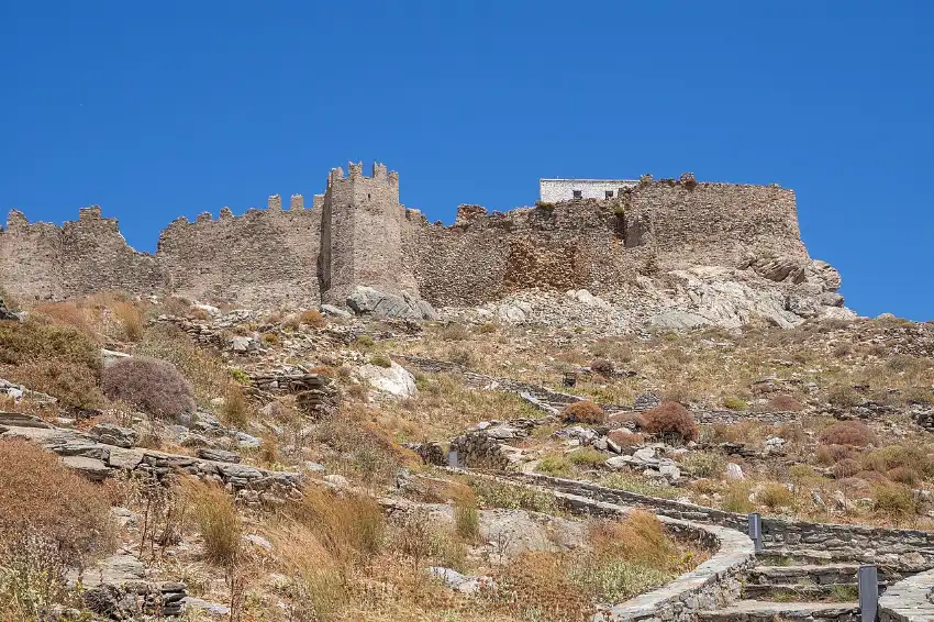
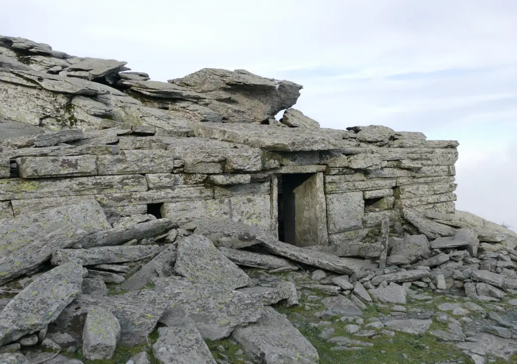
The south is the wild end. Karystos is the southern base, watched over by the medieval Castello Rosso, the “red castle”, on the slope above the town. High on Mount Ochi behind it stands the best known of the Dragon Houses, the Drakospita: ancient dry-stone structures built of massive slabs without mortar, some twenty of them scattered across southern Evia, dated to the classical and Hellenistic centuries and still argued over by archaeologists who cannot agree what they were for. They are among the most unusual things to reach on any Greek island, and worth the climb to see.
The mountains define the interior. Mount Dirfys, the island’s highest peak at about 1,743 m, rises above the village of Steni, which is the walking base for the summit and the forest trails around it. Near Karystos, the Dimosari Gorge is the signature hike, dropping through running water and shade to the sea. Both are walks you do on your own two feet with a map, not tours you book.
The beaches follow the coast’s logic. The exposed east coast faces the open Aegean and runs wilder and windier; the west coast, looking back across the gulf, is gentler and holds most of the organised, family-friendly sand. Which side you swim on comes down to the wind that day, which is one more reason to know whether you will need a car here.
When to go to Evia
The best months for Evia are May, June, September and early October, when the sea is warm enough to swim, the tavernas are open and the crowds are thin. July and August are peak, with the hottest weather and the fullest beaches, while northern Evia, thanks to its thermal springs, also works in winter when most Greek islands have closed.
August is busiest for a specific reason: Evia is where a lot of Athenians take their own summer holiday, so the west-coast beaches and Chalkida are at their fullest and their most domestic-Greek. That is worth knowing rather than avoiding; it is simply not a quiet month.
The shoulders reward a planner. May and late September into October give warm-enough water, open tavernas and room to breathe. Spring is the season for wildflowers, for hiking Dirfys and the Dimosari Gorge before the heat, and for birdwatching if Lake Dystos is holding water.
The winter point is the one the Cyclades cannot match. Because the Edipsos springs run hot all year, the north is a viable cold-weather destination when the postcard islands have shut for the season. For the wider picture, see the best time to visit Greece and Greece weather month by month.
Who Evia suits, and who should skip it
Evia is for the road-tripper. It suits Athens-based or Athens-arriving travellers who want an easy escape without a ferry booking, hikers after real mountains and gorges, spa and wellness seekers drawn to Edipsos, families who want a working, lived-in place, and anyone who prefers a Greek-holiday feel to an international-resort one. Give it a car and a few days and it opens up.
It is the wrong island for two kinds of traveller, and saying so is fairer than pretending otherwise. If you have no car and want to island-hop between ports, Evia’s size works against you. And if your mental image of a Greek island is blue domes and whitewashed lanes tumbling to a caldera, this is not that island: it is large, green-and-brown, mountainous and domestic, and it never set out to be a postcard.
The trade-off is a matter of how the place is built, not a gap in it. Public transport concentrates around Chalkida and thins across a big island, so the whole experience is designed around driving. Come with wheels and a road-trip mindset and Evia rewards you; come expecting to ferry-hop on foot and it will frustrate you. If you want to see how it fits among its neighbours, look at the Sporades and at which Greek islands really need a car.
Practicalities to sort before you go
A car is the through-line of any Evia trip. Bring your own across the bridge, or rent at Athens airport or in Chalkida, and plan the days around driving. This is the single most important thing to sort, so sort it first.
Because you drive on, there is very little to pre-book for access itself, which is a real contrast with the ferry-and-hotel choreography other islands demand. The one thing worth checking ahead is a car ferry to the south or the Edipsos coast in high summer, when crossings are busy; the Rafina to Marmari boat runs daily all year and the Arkitsa crossing takes about three quarters of an hour, but check the day’s sailings before you rely on one.
Carry some cash. Smaller villages and family tavernas may not take cards, and cash smooths the way; the how cards and ATMs work in Greece guide covers the detail. Mobile coverage is good along the populated coasts and patchier up in the mountains, so if you are relying on data for maps, an eSIM to stay connected is worth arranging before you cross.
Set your expectations honestly. Outside Chalkida, Edipsos and the main beach towns, English and tourist infrastructure thin out, and August is loud with Greek families rather than international visitors. For the right traveller that is the appeal, not the drawback. Pack for a road trip with hikes and beaches in it, per what to pack for Greece.
Evia FAQ
Where is Evia, Greece?
Evia (Euboea) is Greece’s second-largest island after Crete, a long, narrow island running down the country’s east coast. The Greek island of Evia is separated from the mainland only by the narrow Euripus strait at Chalkida, and joined to it by bridges about an hour north of Athens.
How do you get to Evia from Athens?
Most people drive: north on the toll A1 motorway, off at Schimatari and across the bridge at Chalkida in about an hour, because Evia is bridged to the mainland and needs no ferry. KTEL coaches from the Liosion terminal take about the same; the direct train from Athens Central Station is slower, nearer an hour and a half. Short car ferries shortcut to the south and the far north. Match your entry point to the end of the island you are sleeping at.
Do you need a ferry to get to Evia?
No ferry is required for most of Evia. Bridges at Chalkida connect the island to the mainland, so you can drive straight on. Short car ferries exist as shortcuts to the southern towns and the northern spa coast, saving you the drive down a long island, but they are optional rather than necessary.
What is the tidal phenomenon at Chalkida?
At Chalkida the current in the narrow Euripus strait reverses direction on a near-daily rhythm: it runs one way for hours, pauses to a dead-still slack for a few minutes, then flows back the other way. It happens because the water on each side of the pinch fills at a different rate, and has been watched since Aristotle’s time. You can see it free from the old bridge.
What is Evia known for?
Evia is known for being Greece’s huge, un-touristy second island a short drive from Athens: the thermal springs of Edipsos, the reversing tidal current at Chalkida, ancient Eretria, the Dragon Houses of Mount Ochi, and mountain walking on Dirfys and in the Dimosari Gorge. It is a road trip rather than a boat holiday.
Is there a lake in Evia?
Evia’s best-known lake is Lake Dystos, in the centre of the island southeast of Aliveri. It is a shallow, seasonal wetland below the ruins of ancient Dystos, valued mainly for birdwatching, and it is often low or dry rather than a full lake, so check the season before planning a visit around water.
Is Evia worth visiting?
Yes, if you want a big, authentic, road-trippable Greek island near Athens with thermal springs, mountains and quiet beaches, and you have a car. It is less suited to travellers who want to island-hop without a car, or who are chasing the whitewashed-Cyclades look, which Evia does not have and never set out to.
Plan by category
The Evia guides
2 guides, each scoped to a decision you actually have to make.
 Attractions
Things to do
See the attractions → Beaches
The beaches
See the beaches →
Booking
We sell nothing and book nothing for you. Every guide on this page tells you how to arrange each piece yourself - which ferry operator, when to book, what to prebook and what to leave loose.